Cloud Properties Using Zenith Radiance Measurement
Last Thursday Warren Wiscombe was in my department (AOSC, Univ of Maryland) to give a talk. Many of us have greatly benefited from radiative transfer code DISORT. He is a co-author to that code. He has written few other excellent algorithms and code for atmospheric remote sensing. His code for the Mie scattering can be downloaded here.
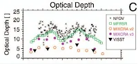
His talk was about deriving cloud properties using ground based zenith radiance measurements. Focus of the talk was cloud optical depth. Cloud optical depth is very important parameter for climate modeling as can be understood from the fact that at any time more than 60% of the earth’s sky is covered with cloud. Cloud optical depth (COD) can range anywhere between 1 and 80+. In spite of such high importance, not only it is poorly understood parameter but also a challenging task to measure it. Turner et al. (2007) highlight this problem by showing five different techniques resulting in five different values for same cloud (see figure).
Warren described narrow field of view zenith radiometer (NFOV) in detail. Unlike aerosol where ground based measurements are concerned mostly with transmitted photons, zenith radiance measurements in presence of cloud have to deal with both transmitted and backscattered photons. When a cloud is thin, increasing cloud optical depth increases number of scattered photons, but after reaching a peak value further increase in cloud optical depth results in attenuation of photons. Hence we are in a situation where we have same radiance value for two different cloud optical depths.
One can overcome this problem using spectral measurements, if geography of a place supports it. Green vegetation reflects predominantly near-infrared-radiation (NIR). If measurements are made at a place, which is surrounded by green vegetation, zenith radiance flux will have spectral signature depending on scattered photons are coming from the Sun (thin cloud) or reflected from the Earth (thick cloud). Wiscombe and his group are developing a new NFOV, which makes measurement over 240 wavelengths bands. That is just in one second!
I highly recommend reading Turner et al (2007) paper to get insight into challenges associated with cloud remote sensing.
Reference
Turner et al. (2007), “Thin Liquid Water Clouds: Their Importance and Our Challenge”, Bull. American Meteo. Soc, vol 88(2), 177-190, DOI:10.1175/BAMS-88-2-177
Correction:
In a reply to my e-mail. Warren has pointed out following about NFOV.
I wrote " One can overcome this problem ... if geography of a place supports it"
It is not geography but only whether or not there is enough green vegetation around, for at least a horizontal distance equal to the vertical distance to cloud base.
I wrote "Wiscombe and his group are developing a new NFOV, which makes measurement over 240 wavelengths bands."
Peter Pilewski of U Colorado developed this spectrometer under contract to ARM. However, Wiscombe and his group urged its development for years and are its biggest users.
His talk was about deriving cloud properties using ground based zenith radiance measurements. Focus of the talk was cloud optical depth. Cloud optical depth is very important parameter for climate modeling as can be understood from the fact that at any time more than 60% of the earth’s sky is covered with cloud. Cloud optical depth (COD) can range anywhere between 1 and 80+. In spite of such high importance, not only it is poorly understood parameter but also a challenging task to measure it. Turner et al. (2007) highlight this problem by showing five different techniques resulting in five different values for same cloud (see figure).

Warren described narrow field of view zenith radiometer (NFOV) in detail. Unlike aerosol where ground based measurements are concerned mostly with transmitted photons, zenith radiance measurements in presence of cloud have to deal with both transmitted and backscattered photons. When a cloud is thin, increasing cloud optical depth increases number of scattered photons, but after reaching a peak value further increase in cloud optical depth results in attenuation of photons. Hence we are in a situation where we have same radiance value for two different cloud optical depths.
One can overcome this problem using spectral measurements, if geography of a place supports it. Green vegetation reflects predominantly near-infrared-radiation (NIR). If measurements are made at a place, which is surrounded by green vegetation, zenith radiance flux will have spectral signature depending on scattered photons are coming from the Sun (thin cloud) or reflected from the Earth (thick cloud). Wiscombe and his group are developing a new NFOV, which makes measurement over 240 wavelengths bands. That is just in one second!
I highly recommend reading Turner et al (2007) paper to get insight into challenges associated with cloud remote sensing.
Reference
Turner et al. (2007), “Thin Liquid Water Clouds: Their Importance and Our Challenge”, Bull. American Meteo. Soc, vol 88(2), 177-190, DOI:10.1175/BAMS-88-2-177
Correction:
In a reply to my e-mail. Warren has pointed out following about NFOV.
I wrote " One can overcome this problem ... if geography of a place supports it"
It is not geography but only whether or not there is enough green vegetation around, for at least a horizontal distance equal to the vertical distance to cloud base.
I wrote "Wiscombe and his group are developing a new NFOV, which makes measurement over 240 wavelengths bands."
Peter Pilewski of U Colorado developed this spectrometer under contract to ARM. However, Wiscombe and his group urged its development for years and are its biggest users.
Comments